Free Shipping over $200 in USA

Garmin Huntview Plus Map Card

Regular price $89.99
Sale price $89.99 Regular price
Sale Sold out
Unit price
/per 
Shipping calculated at checkout.
This is a pre order item. We will ship it when it comes in stock.
Size Chart
 

Vest Sizing

Girth  Weight
Terrier (T) 18-22" 15-25 lbs
Extra Small (XS) 22-26" 25-40 lbs
Small (SM) 26-30" 40-60 lbs
Medium (MD) 28-32" 60-80 lbs
Large (LG) 32-36" 85-115 lbs
Extra Large (XL) 36-40" 115-145 lbs
Double Extra Large (2XL) 40-44" 145-175 lbs 

Cut Collar Sizing

Neck Circumference  Collar Length Collar Width
Extra Small (XS) 14-16" 18" 3.5"
Small (SM) 16-18" 20" 4"
Medium (MD) 18-20" 22" 4"
Large (LG) 20-22" 24" 4"
Extra Large (XL) 22-24" 26" 4.5"
Double Extra Large (2XL) 24-26" 28" 4.5"
  • We recommend utilizing girth measurements over weight when selecting vest sizes.   While weight is sufficient in most cases, girth measurements tend to be the most accurate.  The illustration below will show you where to measure.    
  • NOTICE for Overlap Sizing-  If you have a dog that falls in between on sizing our general recommendation is for wider chested dogs to go up a size and slender built dogs go down a size.
  • These are the typical sizing guidelines.  99% of dogs will fit into these standard sizes, however some dogs do have unique structures and may need a custom fit.  If your dog does not fit into any sizes outlined below, please send us the measurements described at the bottom of the page and we will make a custom vest for you. 
  •  

    Click here for instructions on Measurements


    Product Description


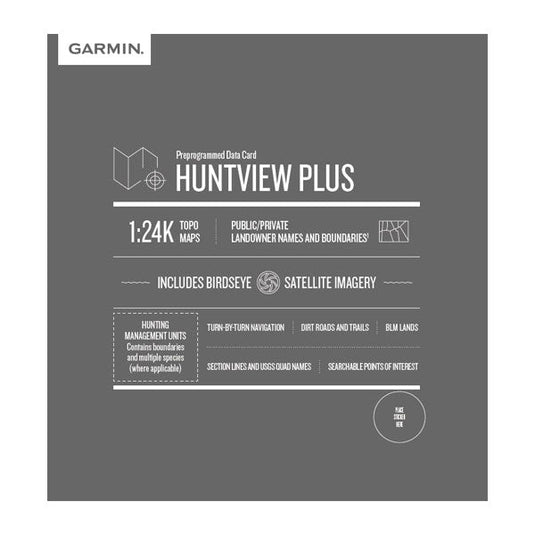
    NOTICE: Please allow an additional 2-3 Days for shipping on Huntview Plus Cards.  These are shipped directly from our Garmin Distributer and may arrive in a separate package if ordered with other products.  

    Track your hunting dogs with exclusive BirdsEye Satellite Imagery and 1:24K scale TOPO mapping, these preloaded microSD™ cards offer a seamless hunting map solution for Garmin handheld GPS devices.

    Map data is collected from multiple sources, providing full state-by-state coverage with routable road and trail data, landowner names and boundaries for public/private land types and boundaries (BLM, National wildlife refuges, National parks, WPA, WMA), food/fuel locations and more. Included BaseCamp™ software lets you interface your computer with your handheld device to plan your hunt, transfer waypoints, and even keep a track log so you can return to the best hunting spots or share the adventure online.

    • Easy-to-use mapping solution for hunters and outdoorsmen – plug-in microSD card eliminates time-consuming downloads
    • Identifies landowner names and boundaries for public/private land types and boundaries, using data from multiple sources for superior coverage and detail
    • Digital topography equivalent to 1:24,000 scale U.S. Geological Survey maps
    • Shows thousands of routable roads and trails with turn-by-turn navigation
    • Includes searchable points of interest: parks, summits, geographic place names, camping areas, businesses, and more
    • Provides Bureau of Land Management township, range and section information, plus USGS quad location
    • Compatible with BaseCamp software for managing data on your GPS and computer, trip planning, playing back routes and tracks, geotagging photos and more
    • Full state coverage for other states, sold individually.


    Notice:  We do not accept returns on opened Map Cards.